Throughout the history of man the Wadi Arabah has always been more of a bridge than a barrier. Settlement patterns on both sides and in the Wadi itself, as well as the material culture on both sides prove again and again that there was frequent interaction between both sides. North-south routes have been found, as well as east-west routes. The Wadi itself was used as a grazing ground by pastoralists, and cultivated by farmers. Its rich sources of copper have attracted people from the Early Bronze Age onwards.
Lower Paleolithic
Abbevillean
Lower and Middle Acheulian
Upper Acheulian
pre-Aurignacian
Mousterien
Phase I:
Emireh, Boqer Tahtit
Phase III-IV: Aurignacian
Geometric Kebaran
Natufian
Pre-pottery
Neolithic
Phase A
Phase B
Phase C
Neolithic
Ghassulian
II
III
3000 - 2700
2700 - 2350
II B-C
1750 - 1550
IIA
IIB
1400 - 1300
1300 - 1200
IAB
IIA
IIBC
1200 -1000
1000 - 900
900 - 586
Early Nabat (late Hell).
Late Nabataean (Early Roman)
200 - 0
0 - 200
Umayyad
Abbasid and Fatimid
Crusader and Ayyubid
Mamluk
Ottoman
700 - 1099
1099 - 1291
1291 - 1516
1516 - 1917
Mandate
Hashemite kingdom Jordan / State of Israel
1948 - present
of the Wadi Arabah
Settlement
History of the Wadi Arabah
Paleolithic to early Neolithic settlement patterns
Compared to later periods, settlement in the Wadi Arabah in the Paleolithic to Neolithic was relatively sparse. Surveys in the region recorded a percentage of 25 – 50 for sites earlier than the Chalcolithic. Within the time-frame for these respective periods, that comes down to an extremely low settlement density for the Pleistocene and early Holocene.
A break-down of the settlement pattern into different level zones shows that the highest concentration of sites is found in the zone that lies1000-1100 meter above sea level (up to 8.1 sites per km2) whereas both the higher and lower zones show a much lower density (ca. 1 site per km2). This suggests that the 1000-1100 zone was optimally conditioned for settlement in these periods. This is borne out by the finds in these sites. In the western Wadi Hisma and Ma’an Plateau, located on the eastern periphery of the Arabah, middle range sites showed a higher density in cultural deposits and artifacts, and a greater variety in archaeological features (e.g.,hearths, petroglyphs, bedrock mortars, architecture) than the higher or lower sites, and suggest seasonal occupation by larger groups, compared to short-term camp sites by smaller groups both in the higher and in the lower levels. At the same time a cultural connection could be established on the basis of the finds, suggesting a transhumance pattern.
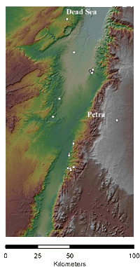
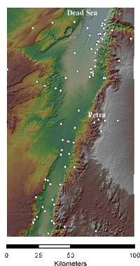
30 Paleolithic sites have been recorded so far. 15 of these were found in the Wadi Fidan, which has been intensively surveyed by Thomas Levy and his team. Most of the remaining sites were found further to the south on the east slopes of the Wadi. Only 4 sites dated to the Paleolithic have been found in the western Wadi Arabah. All recorded sites can be dated in the middle to late Paleolithic, with the exception of one in the Petra region, which is dated to the Epipaleolithic.
The relative paucity of Paleolithic to Neolithic sites that were found in the region must partly be explained by the fact that these older surfaces are buried by Middle and Late Holocene sediments. This is certainly valid for the Southern Arabah, where sites have been found under levels of 3-6 meters of later deposits.
Paleolithic sites in the Wadi Arabah and hinterlandIn the northern Arabah the concentration of late Pleistocene-Early Holocene sites was higher than in the south, but Paleolithic sites were virtually absent here too. Recent research of the water levels of the Dead Sea (or Lisan Lake) has provided a possible explanation for this. The Lisan Lake levels have fluctuated between 160 and 400 m below sea level in the past 100.000 years, with a possible high of 160 mbsl around 15.000 bp, and the processes of deposition and erosion that are connected with these fluctuations have had a strong impact on the older sites in the area, either covering them up, or eroding them away.
Neolithic to Chalcolithic settlement
In the eighth to fourth millennia BC the climate in the desert region, including the wadi Arabah, was milder than it is today. Until recently, habitation of the desert was seen as fluctuating in this period, with relatively short periods of occupation alternating with long periods in which the region was deserted. Recent research, and particularly 14C dating has proven this picture wrong. There are traces of continuous habitation and settlement in the Negev, the eastern Sinai and southern Transjordan.
Sites are generally small, and reveal few artifacts, and the difficulties in dating on the basis of these artifacts are great. At the same time, 14C dating not only shows a continuous settlement pattern in the region, but also a relative longevity for individual sites. It seems that local cultures had a long lifespan, and changes were slow, perhaps because the region was outside the main political centres and their traditional hinterlands, owing to its relatively harsh climate.
Evidence for west-east connections between the Negev and the Jordanian Plateau existed during the Pre-Pottery Neolithic. Green secondary copper ores from the Wadi Arabah, as well as turquoise from the Sinai Peninsula (‘greenstones’), have been found among the beads in settlements such as Ain Ghazal, Basta and Beidha.
Rothenberg has defined two cultures in the Wadi Arabah: the Eilatian Culture, which is defined by a continuation of Paleolithic traditions, including Levallois technique, and the Timnian culture, defined by a finer toolkit, containing tabular scrapers, adzes, knives, but no Levallois technique. Some characteristics were shared by both, perhaps an indication of cultural contact. Both cultures flourished contemporaneously from the sixth to the third millennium. A subdivision, by Rothenberg, into an Early, Middle and Late phase is not generally accepted.
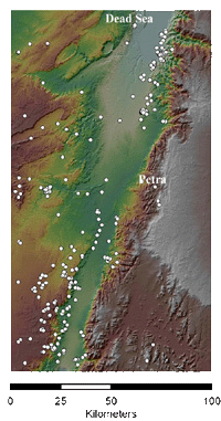
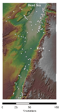
Although it does not seem very useful to group together the entire Neolithic and Early Bronze Age into one settlement pattern map, given the present nature of the evidence we have no choice. Of the 357 sites, 163 are located in the western Arabah dating generally between the sixth and third millennia BC. As it is not possible to be more specific about their dating, we are forced to consider the entire Neolithic and Early Bronze Age together.The pattern on the map reflects the current state of our knowledge; the gaps are survey gaps, not (necessarily) settlement gaps. So, in the north-east Arabah, the density of sites reflects the intensive surveys in the southern Ghors and north-east Arabah and the Jabal Hamrat Fidan, while in the western Arabah the density reflects the sites surveyed and recorded by Avner.
Neolithic to Early Bronze Age sites in the Wadi Arabah and hinterland
Settlement in the Early Bronze Age
The Early Bronze Age in the Negev and adjacent regions is usually linked to the heyday of the town of Arad, in EB II. The general picture is that of Arad as a desert polity, controlling the copper industry in the region, colonizing the south, and causing a sudden upsurge of settlements in the region. The demise of Arad induced a deterioration in the settlement pattern in the desert and a gap in occupation after EB II.
However, recent research, including 14C dates of these sites, shows that they had a much longer lifespan, starting in the Chalcolithic and continuing into EB IV. The Feinan copper industry was flourishing in EB III, a period in which settlement in the Sinai and Negev also flourished, according to the 14Cdates. It seems that the material culture that is generally identified with EB II, notably the use of the holemouth cooking pot and the tabular scraper, had a much longer timespan, starting in the Late Chalcolithic, and continuing into EB III and perhaps EB IV.
The Wadi al-Hasa Archaeological Survey and the Southern Ghors and Northeast Arabah Archaeological Survey have revealed 43 sites with EB I material, as well as sites dated to the Chalco-EB I and EB I-III. Two major sites near ‘Aqaba, Tall Maqass, and Tall Hujeirat el-Ghuzlan, were probably established in the Late Chalcolithic but were mainly occupied during the EB I, and were permanent settlements, existing on a mixed economy of agriculture, pastoralism, copper working and manufacture of seashell artifacts.
In most of the Early Bronze Age the Wadi Arabah and its hinterland, certainly to the west, was a ‘metallurgical province’. Copper from Timna was exported to settlements near Aqaba, and from there possibly to the Nile Delta. Copper from Faynan was exported to sites in the Beersheba basin from the Late Chalcolithic and during the developed EBA. In contrast, there is no evidence yet for the distribution of copper from the Arabah to the east. Therefore it seems that, at least for the copper ore and metal from Faynan and Timna, the actual barrier was not the desert landscape of the Wadi Arabah, but much more the steep ascent to the Jordanian Plateau.
The Wadi Arabah in the Middle and Late Bronze Ages
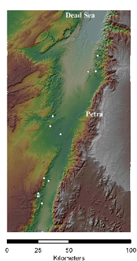
There is little evidence for a Middle or Late Bronze Age presence in the Wadi Arabah. With only 20 sites currently attributed to the Middle-Late Bronze Ages, this is the lowest incidence for any period, including the Palaeolithic (although the incidence of sites is relative, since the ‘periods’ are all of different length). On the west side the copper mines of Timna were exploited by the Egyptian empire during the Late Bronze Age. Midianite sherds (otherwise known as Qurayyah Painted Ware) have been found in Timna, and on several sites in the Wadi and in the Negev, suggesting contacts between the Arabian Peninsula and the Negev, through the Wadi. Domestication of the camel in this period certainly made long-distance trade between east and west an option for the first time. On the other hand, there is evidence that Midianite pottery remained in use until well into the Iron Age. On the east side, three sites have been identified with a few possible Late Bronze sherds: Tell es-Safi, Khanazir and a site in the wadi Fidan. So it seems that only for the site of Timna is there firm evidence for settlement in the Late Bronze Age. Middle to Late Bronze Age sites in the Wadi Arabah and hinterland On the other hand, there is textual evidence showing that non-settled, or partly settled groups roamed the area on both sides of the Wadi. Egyptian sources from the end of the Middle Bronze Age and the Late Bronze Age mention the presence in the area of Shasu. Shasu were not a settled people, and are described as wandering pastoralists, and raiders of caravans. The sources seem to imply that their home territory was east of the Wadi Arabah, in the Edom highlands, where they had strongholds. But there are also indications that they were found on the west side, in the Negev and Sinai. Papyrus Anastasi IV, a letter from the time of Merneptah mentions the passage of the Shasu-tribes from Edom to the pastures of Per Atom in Tjekku in order to feed their flocks, suggesting that they crossed the Wadi on a regular basis.
Settlement and trade in the Iron Age
At the beginning of the Iron Age, the mining site of Timna was deserted by the Egyptians. Smelting site 30 continued into the 12th century, and was briefly reoccupied in the 10th century.
On the east side some Iron Age I sherds have been found at Telah, at Khanazir and at Safi, in the Ghor es-Safi, just south of the Dead Sea. Apart from that, the earliest evidence of occupation on the east side dates to the 10th century: the Wadi Fidan 40 cemetery, which may have belonged to a local nomadic group. Recent investigations in the Wadi Feinan, such as Khirbet en-Nahas and Barqa el-Hetiye, suggest a more intensive exploitation of the region, including small settlements, starting at the end of Iron Age I or the beginning of Iron Age II.
In the Negev intensification of settlement started in Iron Age I with the settlement of Tel Masos, followed by several 11th century settlements in the Beersheba valley. Whether this early settlement was related to the United Monarchy, and later the Kingdom of Judah, or whether it was the result of intensification of mining activities in Feinan, and/or the Arabian trade, is still a matter of debate. The eighth to sixth centuries saw a further intensification of settlement on both sides of the Wadi Arabah, and the material culture indicates contact between the two sides. However, there was still little settlement in the Wadi itself, as the settlement patterns show. This does not mean that there was no activity. The Arabian trade route crossed the Wadi on its way to Gaza and Egypt, and mining activities in the Wadi Feinan peaked in the Iron Age II, exporting copper to the west. The fortress and shrine at En Haseva in the western Wadi Arabah may well have been a way station for the trade route, and the mixed character of the pottery repertoires of the Beersheba valley and of Tell Kheleifeh sites suggest international contacts on a regular basis. The economic basis of the kingdom of Edom may well have been a combination of international trade and copper production. The Assyrian empire (and perhaps later the Neo Babylonian) demanded tribute from Edom, as a vassal state, but there is no indication that either empire was actively involved in the economy of Edom.
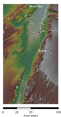
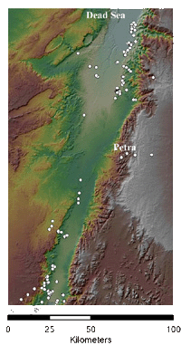
Again, due to the difficulty of dating Persian period sites (see below) the Iron Age and Persion period sites have been plotted together on one map. These 121 sites reflect the pattern of surveys rather than a genuine settlement pattern. In the north-east is a considerable density of sites recorded by intensive surveys in the north-east Arabah and Jabal Hamrat Fidan; opposite, on the western side, are En Hazeva and a line of Iron II sites surveyed by Cohen along the known Iron Age route towards the Beersheba Valley. To the south on the eastern side of the Arabah is virtually nothing except the known Iron II sites in the Petra region and Tall al-Khalifa on the Gulf of Aqaba .
The south-western side is quite different: all of the currently recorded sites are Iron I, including the fort at Yotvata, and copper-smelting sites and associated installations at Timna and Nahal Amram. Curiously, no Iron II sites are apparently recorded so far from this region.
Iron Age to Persian period sites in the Wadi Arabah and hinterland.
The Persian Period
Only three sites in southern Jordan have revealed clear evidence of Persian material: Busayra, Tawilan and Tell el-Khelayfe. On the other hand, recent research is making it more and more clear that the local pottery repertoires from the late Iron Age II continued well into the Persian period virtually unchanged. It is therefore likely that settlement in the Persian period was more extensive than has hitherto been assumed. In the Negev the main sites with Persian-period material are on the desert routes: Arad, Tel Ira and Tel Sheva in the Beersheba valley, and a number of possible fortresses on the road from Arad to Kadesh-Barnea and Egypt. Some sites, notably Arad, Tel Sheva and Tell el-Khelayfe produced large numbers of ostraca, mentioning personal names and quantities of goods, such as wheat and wine, possibly provisions, or trade goods. The ostraca are generally dated to the 4th century, and the personal names indicate a mixed population with a large Edomite element, suggesting that in this period there was free and frequent interaction between both sides of the Wadi Arabah.
Hellenistic and Nabataean sites
110 sites of the early Nabatean and Hellenistic period have been recorded, with the highest concentration in the northeast Arabah. Again, this reflects the areas of intense survey, rather than actual settlement patterns. Clusters of Nabatean sites have also been found in the Petra region, and along the connecting Wadis into the Arabah.
Hellenistic and Nabatean sites in the Wadi Arabah and hinterland
The Nabataeans are first mentioned by Diodorus Siculus in the first century BC, quoting an earlier work by Hieronymus of Cardia dated to the fourth century BC. They were a wealthy Arab tribe that transported valuable products such as frankincense and myrrh from Arabia ‘down to the sea’ at Gaza. Gaza was accessed by overland routes leading from Petra to the north-west, through the Wadi Arabah, across the Negev Highlands and down into the coastal plain. There is archaeological evidence of the presence of Nabataeans in the Late Hellenistic period at Petra and several sites in the Negev, such as Elusa, Nessana and Oboda.
Hilltop forts have been found in the central Wadi Arabah, the southern edge of the Dead Sea and the central Negev, dated to this earliest phase of Nabataean activity. They were located at Moa (Moyat Awad), north-west of Petra on the western side of the Wadi Arabah, ‘En Tamar next to the Dead Sea, and ‘En Ziq in the Nahal Zin basin. Next to the springs of ‘En Erga and ‘En Rahel two more forts have been excavated. They were defensive, with a clear view of the surrounding area and roads.
The capture of Gaza by the Hasmonaean king of Judah Alexander Jannaeus shortly after 100 BC put a temporary stop to the Nabataean trade, and the trade routes were abandoned.
Towards the end of the first century BC the Nabataeans returned to the Negev, this time permanently. Their activities in this period were focused on building a network of roads and caravan stops, first at the sites abandoned since the beginning of the first century BC and eventually at new places along secondary roads. By the middle of the first century AD traffic along the route appears to have increased considerably and two large caravanserais were constructed at Moa and Sha’ar Ramon. Caravanserais have also been found in the southern Wadi Arabah at Dafit, a Nabataean site located north of Aqaba, and at Rujm Taba on the eastern side of the Wadi Arabah opposite Yotvata.
The Roman annexation of Nabataea in 106 may well have been aimed at taking over the profitable trade routes. Trade continued uninterrupted, and the material culture found at many of the Negev sites shows that the Nabataeans were still involved in the trade.
After the collapse of international trade in the third century the Nabataeans turned to agriculture and the trade in agricultural products, particularly wine, as their primary means of subsistence. It is probable that this development was prompted by the increased presence of Roman forces in the region from the Diocletianic period, when the Tenth Legion was transferred from Jerusalem to Aila on the Gulf of Aqaba. Roman military activity intensified at ‘En Hazeva in the central Wadi Arabah with the construction of a fort, a cavalry camp and bathhouse at the site. The focus of military activity in the Negev and southern Jordan in this period probably bolstered relations between the populations in these two regions.
Roman texts, as well as the presence of a number of milestones in the Wadi show that there was a road running from Jerusalem, through the Wadi Arabah to Aila, probably constructed by the Romans in the late 3rd century.
Ceramic assemblages found at Negev sites in this period, and particularly those sealed by the earthquake destruction of AD 363, point to continued ties with Petra and southern Jordan. Only in the fifth century would these finally disintegrate.
233 Late Roman and Byzantine sites have been recorded in the Wadi Arabah and hinterland so far, making this the second most intensive period of use for the Wadi, after the Neolithic - Early Bronze period.
One factor stands out in comparison to current evidence from other periods: the multiplicity of clear routes in different directions (to be considered alongside the construction of the Via Nova Traiana to the east of the Arabah in the early second century AD). To the north-west of the Faynan region, heavily settled and exploited in these periods, is a line of Roman sites reflecting the known route to Gaza through Ma’aleh ‘Aqrabbim, the so-called Scorpions’ Ascent.
West of Petra is the Roman-period continuation of the Petra-Gaza road, which continued at least as late as the third century AD. South of Gharandal, along the bottom of the wadi, are portions of a north-south paved road, and concentrations of Late Roman milestones presumably marking a north-south-road.
Roman and Byzantine sites in the Wadi Arabah and hinterland
Although currently 146 Islamic-period sites are recorded, it must be acknowledged that the data are not very useful for an overall picture:
Islamic-period sites in the
Wadi Arabah and hinterland
The Islamic period covers a chronological span of more than a thousand years, but much of the survey data is quite blunt, often recording material as simply ‘Islamic’ with no further chronological subdivision. However, the survey data from the Southern Ghors and Northeast ‘Arabah Archaeological Survey does attempt, where possible, to refine the dating according to the Islamic dynasties. This evidence indicates that during the Early and Middle Islamic periods the north-east Arabah was a fertile region for the growing and processing of sugar cane and indigo. The Peutinger map, a thirteenth-century copy of a Roman world map shows a road from Zoar (Islamic Sughar, modern Safi), round the southern end of the Dead Sea, down to En Hazeva. This is probably also the route used by Baldwin I’s expedition in 1100, when the crusaders marched from Hebron, crossed the Wadi Arabah near Zoar, then marched down to Petra. Baldwin IV also used this route when he went to relieve Karak in 1183. There is also ceramic and historical evidence for activity in the north-east Arabah in the Late Islamic (Ottoman) period, although the archaeological evidence suggests a decrease in population, with human presence confined to sherd scatters which represent potbusts and possibly camps, perhaps reflecting a largely pastoral nomadic population.Notwithstanding the comments above, virtually all the ‘Islamic’ sites in the western Arabah are dated to the Early Islamic period. In the south-west Arabah, the data reflects the pattern analysed by Avner and Magness (1998), while the group of sites in the north-west, apparently along the route towards the Beersheba Valley and Gaza, reflects identification of Early Islamic pottery on Roman sites. Early Islamic settlements in the hinterland of Ayla were involved in large-scale agriculture, copper and gold mining and production, stone quarrying, and the development of a road network used by merchants and pilgrims.
The central Arabah is still suspiciously empty of recorded Islamic sites, with the result that it is still possible to accept King’s 1989 hypothesis that routes across the central Arabah declined from the Early Islamic period because of a new pattern of communications. This would support the views of Avner and Magness (1998) and Whitcomb (2006) that sites in the southern and northern Arabah functioned as a resource hinterland for Ayla and Sughar/Zoar/Safi respectively, providing agriculture, sugar, mining and metallurgy. While this picture may turn out to be correct, it is worth remembering the limitations of the evidence. The central Arabah is still to be intensively surveyed and, although the wadi is not specifically mentioned, we might expect slightly more activity there given the agricultural importance of adjacent areas as recorded by early Islamic geographers, e.g. al-Muqaddasi, writing in c. AD 985. For the Late Islamic period, too, we must take into account the evidence of bedouin relations and activity across the Wadi Arabah (see below).
Recent history
In recent centuries the Wadi Arabah was the stage for interaction between the bedouin and other tribes that lived on both sides of the rift. On the east side were the Howeitat, Sa’idiyin, Umran, Beni Atiyeh, Masa’id, Beni Okba, Bili and Hajaja. On the west side, roaming the Negev and the Sinai, were the Tarabin, `Azazma, Tiyaha, Aheiwat, Wuheidat, and Zullam. Three of these tribes also had grazing grounds in the Wadi itself: the Aheiwat, the Umran and the Sa’idiyin.
Because of the weakness of the Ottoman government in this period, these tribes were practically independent and controlled the social relations and the economy of the region. There were main markets in Gaza and Cairo, which were visited by tribesmen from east of the Wadi on a regular basis, in order to sell and buy. On the east side the main market was in Ma’an, which was a major stop for the annual Hajj pilgrims, and where a family could earn enough in four days to sustain it for the rest of the year. The Howeitat were great camel breeders, and controlled most of the trade across the Wadi.
Raids were also conducted on both sides of the Wadi. Oral traditions among the Negev tribes recount stories of eastern tribes invading the desert, raiding camels or looking for pasture. Nineteenth-century travellers on the Kerak Plateau describe raids by the western tribes on the eastern Plateau tribes.