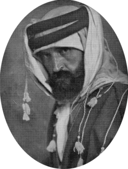
Alois Musil often travelled in Arab dress, and under the name of Sheikh Musa er-Rweili
The first exploration of the Wadi Arabah which recorded archaeological remains was by the Czech Alois Musil in 1898 and again in 1902 (Alois Musil, Arabia Petraea, Band II, Edom: Topographischer Reisebericht, Teil 1, pp. 241-310; Arabia Petraea, Band II, Edom: Topographischer Reisebericht, Teil 2, pp. 178-215).
|
Alois Musil often travelled in Arab dress, and under the name of Sheikh Musa er-Rweili |
Fritz Frank, a German born in Wilhelma, a Templars’ colony in Palestine, and suspected of being a German spy during the First World War, conducted archaeological surveys in the Arabah during the winters of 1932 and 1933/34 (Fritz Frank, ‘Aus der Araba I: Reiseberichte’, ZDPV 57 (1934), pp. 191-280).
Nelson Glueck directed the first truly systematic archaeological survey of the Wadi Arabah as part of his wider survey of Eastern Palestine in 1934 (Nelson Glueck, ‘Explorations in Eastern Palestine, II’, Annual of the American Schools of Oriental Research 15 (1935), p. 1-53.), followed by an aerial reconnaissance in 1939 (Nelson Glueck, ‘An Aerial Reconnaissance in Southern Jordan’, Bulletin of the American Schools of Oriental Research 67, pp. 19-26). He found relatively few sites in the Wadi itself, partly because of his survey methods, which were largely dependent on information from the local inhabitants. However, he found many sites on the eastern flanks of the Wadi, and his aerial reconnaissance uncovered new features in the Wadi itself, such as the Nabataean agricultural terraces at Telah.
Glueck 1939: Aerial photograph of the Nabataean agricultural terraces of et-Telah
In the early 1950s Glueck continued his survey activities in the Negev desert.
His was the first attempt to construct an overall occupational history of the desert. He recorded about a thousand sites in the Negev. His basic outline was the distinction between periods of settlement and gaps. The periods of settlement he identified were the Chalcolithic (almost totally restricted to the Beersheba Basin), Middle Bronze I, Iron Age II, and the Hellenistic-Roman-Byzantine periods, with some continuation into the Umayyad period. The gaps between settlement were the Early Bronze through Late Bronze Ages, Iron Age I, the Persian period, and the period from the eighth century AD to the present.
The Wadi Arabah became an official border between Palestine and Transjordan in 1922, and since the creation of the modern states of Jordan (1946) and Israel (1948) archaeological work has proceeded independently on the two sides.
The western (Israeli) side of the Wadi Arabah has been surveyed as part of numerous surveys conducted in the Negev. Beno Rothenberg conducted extensive surveys in the Negev and Sinai, including the Wadi Arabah, and intensive survey and excavation at the copper-production centre of Timna, from 1959 to 1990 (e.g. B. Rothenberg, Timna’: Valley of the Biblical Copper Mines, London 1972). Rothenberg recorded 216 sites in the Arabah, including those discovered earlier by Musil, Frank and Glueck, while 41 additional sites were undated. The periods of settlement he identified were the Chalcolithic, Iron Age I (mainly related to copper production), the Nabataean, Roman, Byzantine and Islamic periods, with gaps between them.
Ramesside smelting camp (site 30). The camp is surrounded by a defensive wall with two gate towers. The dark areas within the wall are smelting slag on the site of hte copper furnaces. The rough stone structures on the right are the remains of workshops and habitations. In the background are the Timna cliffs with the ancient copper mines at the foot (from: Rothenberg B., Timna: Valley of the Biblical copper mines, 1972)
Significant progress in the survey of the area was made during the Negev Emergency Survey, conducted by Rudolf Cohen from 1979 to 1990, the purpose of which was to document the areas of the Negev to which the Israeli Army was to redeploy following the peace treaty with Egypt. Ten teams worked on the project, and systematically surveyed about 5,000 sq. km. of the area. More than 12,000 archaeological sites were recorded, compared with 1,000 known until then. In recent years hundreds of new sites have been surveyed by Uzi Avner. Results show that the Eilat region in the southern Arabah is the richest in archaeological sites in the southern Negev, despite being the most arid. Approximately 1500 sites have been recorded to date in an area of 1200 sq. km. The settlement pattern emerging from these surveys and excavations shows a continuous occupational sequence covering the last 10,000 years, from PPNB to the present, with no gaps.
On the eastern (Jordanian) side, the first work to follow Glueck’s survey was by a British engineer, Thomas Raikes, who recorded sites during the building of the new road through the Wadi Arabah between 1967-69 and 1975-79 (T. Raikes, ‘Ancient Sites in the Wadi Arabah and Nearby’, unpublished Report (1976); ‘The Character of the Wadi Araba’, Studies in the History and Archaeology of Jordan 2 (1985) 95-101).
Thomas Raikes' detailed drawing of the Wadi Fidan Gorge, part of a larger drawing that covered the eastern Wadi Arabah (Raikes: The Character of the Wadi Arabah, SHAJ 1985)
In 1982 Islamic sites along the wadi were investigated by Geoffrey King (Annual of the Department of Antiquities of Jordan 31 (1987), 33 (1989)). Since then a considerable amount of survey and excavation has been carried out.
The three largest surveys in the Arabah itself have been the Southeastern Arabah Archaeological Survey, a component of Tom Parker’s Roman Aqaba Project, conducted between 1994 and 1998, which recorded approximately 330 archaeological sites (A.M. Smith II, M. Stevens and T.M. Niemi, ‘The Southeast Arabah Archaeological Survey: A Preliminary Report on the 1994 Season’, Bulletin of the American Schools of Oriental Research 305 (1997): 45-71); the Southern Ghors and Northeast Arabah Survey (B. MacDonald et al., The Southern Ghors and Northeast Araba Archaeological Survey. Sheffield Archaeological Monographs 5. Sheffield 1992); and the Wadi Arabah section of the South Jordan Project, concentrating on prehistoric sites (D.O. Henry et al., ‘Survey of Prehistoric Sites, Wadi Araba, Southern Jordan’, Bulletin of the American Schools of Oriental Research 323 (2001), 1-19).
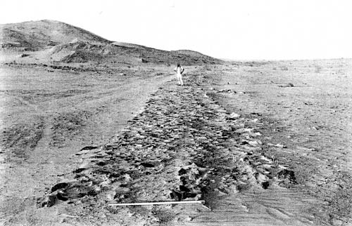
A stone-paved road, site 101 of the Southeast Araba Archaeological Survey by Smith, Stevens and Niemi (BASOR 305, 1997)
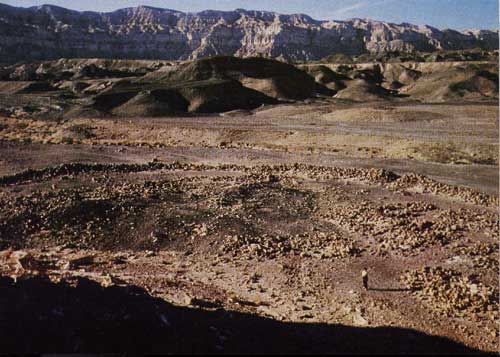
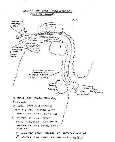
There has been a great deal of archaeological work done in the Wadi Fidan and Faynan regions, which run into the Wadi Arabah, over the past 30 years. Hauptmann et al. of the German Mining Museum, Bochum, Germany, began a series of archaeometallurgical explorations and mining-archaeological studies in the Wadi Fidan region with a preliminary investigation in 1983. This work has resulted in a vastly increased knowledge of the periods when this area was mined, the sites used for mining and smelting activities, and the technology employed, especially during the earliest periods. Levy et al., beginning in the 1990s, are continuing this work with emphasis on sites in the area of Khirbat Hamra Ifdan and more recently Khirbat en-Nahas (T.E. Levy et al., ‘The Jabal Hamrat Fidan Project: Excavations at the Wadi Fidan 40 Cemetery, Jordan (1997)’, Levant 31 (1998), 293-308; ‘Early Bronze Age Metallurgy: A Newly Discovered Copper Manufactory in Southern Jordan’, Antiquity 76 (2002), 425-37). The area of Faynan has been surveyed comprehensively by a British team (e.g. G. Barker et al., ‘Environment and Land Use in the Wadi Faynan, Southern Jordan: The Second Season of Geoarchaeology and Landscape Archaeology (1997)’, Levant 30 (1998), 5-25).
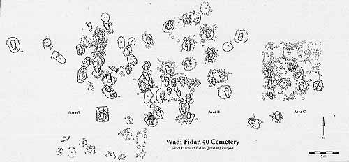
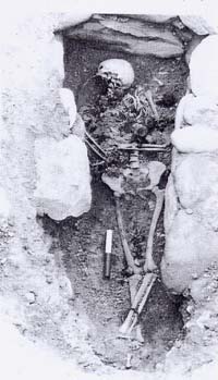
Iron Age cemetery in the Wadi Fidan, possibly belonging to a group of nomadic metalworkers. (Levy et al, Levant 1997)
Alongside Tom Parker’s Roman Aqaba project (e.g. T. Parker, ‘The Roman `Aqaba Project: The 2000 Campaign’, Annual of the Department of Antiquities of Jordan 46 (2002), 409-28, The University of Chicago’s Aqaba Archaeological Project, directed by Don Whitcomb, began as an effort to save an urban Islamic site located in the heart of the modern city (e.g. D. Whitcomb, ‘Excavations in Aqaba: First Preliminary Report’, Annual of the Department of Antiquities of Jordan 31 (1987), 247-66). Excavations began in 1986 and, from 1995, conservation and continued research has continued by Sawsan Fakhry of the Department of Antiquities. Chalcolithic sites in the vicinity of Aqaba have been investigated by a German-Jordanian team (e.g. R. Eichmann and L. Khalil,.‘German-Jordanian Archaeological Project in Southern Jordan: Archaeological Survey and Excavation in the Yitim and Magass Area, 1998 (ASEYM 98)’, Occident and Orient 3 (1) July 1998: 14-16).
The biggest gaps in archaeological survey coverage remain the north-west Arabah (where the paucity of recorded sites contrasts markedly with the density of sites known on the eastern side from the Southern Ghors and Northeast Araba Survey), and the central Arabah on both western and eastern sides: several small-scale surveys on the west-central side remain unpublished, while the east-central side is still known largely from the unsystematic surveys of Raikes and King.