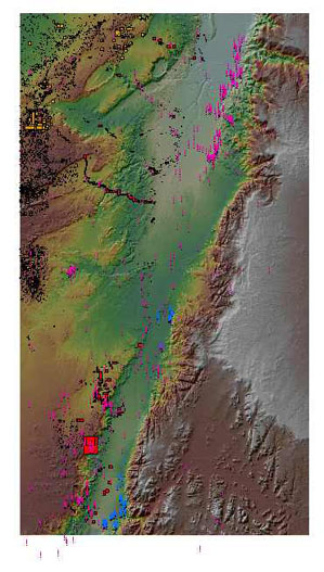
This is a map of the Wadi Arabah, based on a digital terrain model, and showing the sites that have been found by various survey expeditions.
The red rectangles represent sites within the actual Wadi Arabah, and on 'routes' leading into the Wadi, found by the Israel Antiquities Authorities (mostly unpublished); the yellow dots represent all other sites in the Wadi hinterland found by the IAA.
The purple dots represent all sites from other published surveys, as well as those from unpublished surveys that have been made made available by colleagues. The blue dots are sites found by the Southeast Araba Archaeological Survey.
The total number of sites is c. 6000; the total number of sites within the actual Wadi is c. 1000. The digital terrain model on which the sites are projected has been developed by the Geological Survey of Israel.To see a specific section of the map enlarged, click on the map.
| |