|
|
|
Wadi
Arabah as a potential
World Heritage Site
Introduction
The United Nations Educational, Scientific and Cultural Organization (UNESCO) seeks to encourage the identification, protection and preservation of cultural and natural heritage around the world considered to be of outstanding value to humanity. They include monuments, groups of buildings and properties with historical, aesthetic, archaeological, scientific, ethnological or anthropological value, as well as outstanding physical, biological and geological formations, habitats of threatened species of animals and plants and areas with scientific, conservation or aesthetic value.
At present there are two World Heritage sites in Israel (Acco and the White City of Tel Aviv), two in Jordan (Petra and Qusair Amra), as well as the Old City of Jerusalem.
The World Heritage Committee requests State Parties to submit a tentative list of properties which it intends to nominate for inscription to the World Heritage List during the following five to ten years. In order to apply for World Heritage status for a site, the State or States in whose territory the site lies must have it put on the tentative list first.
The Israel World Heritage Committee, headed by Michael Turner, is aiming to put the Jordan Rift Valley on the tentative list of World Heritage sites. The Wadi Arabah forms a trans-boundary serial site (an independent part of a larger site), for which an application must be submitted by the joint Israeli and Jordanian governments. The Wadi Arabah, as part of the Jordan Rift Valley, would qualify as a ‘cultural landscape’.
Cultural landscapesA cultural landscape is defined by UNESCO as combined works of nature and of man, illustrative of the evolution of human society and settlement over time, under the influence of the physical constraints and/or opportunities presented by their natural environment and of successive social, economic and cultural forces, both external and internal. It should be selected on the basis both of its outstanding universal value and of its representativity in terms of a clearly defined geo-cultural region and also for its capacity to illustrate the essential and distinct cultural elements of such regions. It has developed its present form by association with and in response to its natural environment. Cultural landscapes often reflect specific techniques of sustainable land-use, considering the characteristics and limits of the natural environment they are established in, and a specific spiritual relation to nature. Protection of cultural landscapes can contribute to modern techniques of sustainable land-use and can maintain or enhance natural values in the landscape. The continued existence of traditional forms of land-use supports biological diversity in many regions of the world. The protection of traditional cultural landscapes is therefore helpful in maintaining biological diversity.
The Wadi Arabah as a Cultural Landscape
The role that the Wadi Arabah played in the interaction between southern Jordan and the Negev, from the Palaeolithic to the present, defines it as a unique cultural landscape. The nature of this cultural interaction was both defined and shaped by the geological and ecological features of the wadi.The Wadi Arabah is part of the great African-Syrian Rift System. It runs south - north from the Red Sea to the Dead Sea, over 165 km. The present border between Israel and Jordan runs along the wadi. The Wadi Arabah can be divided into a southern part, with the level of the wadi floor rising from sea level at the Gulf of Aqaba to 200 m above sea level by Gharandal, and a northern part, from Gharandal to the Dead Sea, where the valley floor descends to 400 m below sea level. The wadi is flanked on the west side by an escarpment which rises up to 600 m above sea level, and on the east side by an escarpment and a plateau which rise up to 1000 m above sea level. Rainfall in the wadi is low, and temperatures can be high, but seasonal wadis from both east and west drain into the Wadi Arabah in winter, and there are a number of springs, especially along the eastern escarpment.
The Anchor Bible Dictionary describes the Wadi Arabah in the following words: ‘This region is a depression in the earth, for the most part below sea level, which provided a natural barrier and a border between Israel and her neighbors Ammon, Moab, and Edom to the east’.
It has been described as a desolate, barren region, devoid of life. This supposed barrenness, the idea of the Wadi Arabah as a boundary, and the modern political border which runs along the wadi, have all tended to condition a lot of modern interpretation of it as a barrier, as something physically and effectively separating southern Jordan from the Negev.
However, archaeological research on both sides shows that the wadi and its adjacent regions are full of archaeological remains. To date 6000 sites have been found in the region, and there are still large areas that have not been surveyed. The number of sites will probably be doubled in the future. The nature of the material culture on both sides of the wadi from the Palaeolithic onwards shows that there was interaction and exchange between southern Jordan and the Negev on a regular basis, and underlines the intensive contacts between east and west.
We must look afresh at the whole of southern Jordan and the Negev in antiquity. Rather than treating them as two separate areas, divided by the Wadi Arabah, we must reconsider them as two parts of the same socio-economic system, with the Wadi Arabah as a dynamic interface linking them.
It is this function as a bridge which makes the Wadi Arabah unique. The wadi is the key to the proper understanding of the history of the region in all prehistoric and historic periods.
The catalyst for use and occupation of the Wadi Arabah was always exploitation of resources – water, fertile soil, copper – and trade, both in copper from Feinan and Timna and the frankincense route from Arabia to the Mediterranean. The chief barrier to crossing the Wadi Arabah was not physical, but the social relations between people on different sides: this is a situation fleshed out by ethnographic evidence from the nineteenth and twentieth centuries when tribes with different customs and dialects lived on western and eastern sides and were wary of each other and occasionally fought, but still negotiated movement across each others’ areas, took refuge, and created alliances against common enemies.
Both the east and the west side have major fields of copper ore. Originally they were one field, which was split when the rift was created, and owing to tectonic movement they are now 60 km apart. Both the western one, at Timna, and the eastern one, in the Wadi Feinan, have been exploited intensively from the Chalcolithic on, and in most periods they were the largest copper production centre and the major provider of copper for the southern Levant. The impact of this industry on the economy, social organization and settlement patterns of the southern Levant can hardly be overestimated. Timna and Feinan also provide a unique source of information about development of the technology of copper mining, smelting and working from the earliest time that copper was used, the Chalcolithic, until the Byzantine period. Research into both the technological and the social aspect of this industry is well under way.
Sources from the late Iron Age and later show that the wadi was a major crossing point for the Arabian trade to Gaza and Egypt. The camel caravans that carried frankincense, myrrh and other exotic goods from Arabia and India through the desert gathered in great trading centres such as the rock-cut town of Petra, before entering the Wadi Arabah and moving on to the Mediterranean coast and Egypt. Petra became the capital of the tribal kingdom of the Nabataeans, which extended on both sides of the Wadi Arabah. The Nabataeans also exploited the natural resources of the Wadi Arabah to the full, and the remains of their cultivation terraces are still visible in places in the wadi, although they are rapidly disappearing. Cultural remains on both sides of the wadi show that the trade between east and west flourished from an early period on.
There are at least two reasons why the Wadi Arabah forms a cultural landscape of outstanding universal value:
• because it is a major crossroad on the Arabian trade route, which ran from Saudi Arabia to the Mediterranean coast and Egypt, with a vital gateway function
• because it was the centre of copper industry for a large region, and as such provides unique information about all stages of the copper industry: mining techniques, smelting and general copper working, and the economic influence of this major industry on the region in all periods.
|
Introduction
The United Nations Educational, Scientific and Cultural Organization (UNESCO)
seeks to encourage the identification, protection and preservation of cultural
and natural heritage around the world considered to be of outstanding value
to humanity. They include monuments, groups of buildings and properties with
historical, aesthetic, archaeological, scientific, ethnological or anthropological
value, as well as outstanding physical, biological and geological formations,
habitats of threatened species of animals and plants and areas with scientific,
conservation or aesthetic value.
At present there are two World Heritage sites in Israel (Acco and the White
City of Tel Aviv), two in Jordan (Petra and Qusair Amra), as well as the Old
City of Jerusalem.
The World Heritage Committee requests State Parties to submit a tentative
list of properties which it intends to nominate for inscription to the World
Heritage List during the following five to ten years. In order to apply for
World Heritage status for a site, the State or States in whose territory the
site lies must have it put on the tentative list first.
The Israel World Heritage Committee, headed by Michael Turner, is aiming to
put the Jordan Rift Valley on the tentative list of World Heritage sites.
The Wadi Arabah forms a trans-boundary serial site (an independent part of
a larger site), for which an application must be submitted by the joint Israeli
and Jordanian governments. The Wadi Arabah, as part of the Jordan Rift Valley,
would qualify as a ‘cultural landscape’.
|
|
The Wadi Arabah as
a Cultural Landscape
The role that the Wadi Arabah played in the interaction between southern Jordan
and the Negev, from the Palaeolithic to the present, defines it as a unique
cultural landscape. The nature of this cultural interaction was both defined
and shaped by the geological and ecological features of the wadi.
The Wadi Arabah is part of the great African-Syrian Rift System. It runs south - north from the Red Sea to the Dead Sea, over 165 km. The present border between Israel and Jordan runs along the wadi. The Wadi Arabah can be divided into a southern part, with the level of the wadi floor rising from sea level at the Gulf of Aqaba to 200 m above sea level by Gharandal, and a northern part, from Gharandal to the Dead Sea, where the valley floor descends to 400 m below sea level. The wadi is flanked on the west side by an escarpment which rises up to 600 m above sea level, and on the east side by an escarpment and a plateau which rise up to 1000 m above sea level. Rainfall in the wadi is low, and temperatures can be high, but seasonal wadis from both east and west drain into the Wadi Arabah in winter, and there are a number of springs, especially along the eastern escarpment.
The Anchor Bible Dictionary describes the Wadi Arabah in the following words: ‘This region is a depression in the earth, for the most part below sea level, which provided a natural barrier and a border between Israel and her neighbors Ammon, Moab, and Edom to the east’.
It has been described as a desolate, barren region, devoid of life. This supposed barrenness, the idea of the Wadi Arabah as a boundary, and the modern political border which runs along the wadi, have all tended to condition a lot of modern interpretation of it as a barrier, as something physically and effectively separating southern Jordan from the Negev.
However, archaeological research on both sides shows that the wadi and its adjacent regions are full of archaeological remains. To date 6000 sites have been found in the region, and there are still large areas that have not been surveyed. The number of sites will probably be doubled in the future. The nature of the material culture on both sides of the wadi from the Palaeolithic onwards shows that there was interaction and exchange between southern Jordan and the Negev on a regular basis, and underlines the intensive contacts between east and west.
We must look afresh at the whole of southern Jordan and the Negev in antiquity. Rather than treating them as two separate areas, divided by the Wadi Arabah, we must reconsider them as two parts of the same socio-economic system, with the Wadi Arabah as a dynamic interface linking them.
It is this function as a bridge which makes the Wadi Arabah unique. The wadi is the key to the proper understanding of the history of the region in all prehistoric and historic periods.
The catalyst for use and occupation of the Wadi Arabah was always exploitation of resources – water, fertile soil, copper – and trade, both in copper from Feinan and Timna and the frankincense route from Arabia to the Mediterranean. The chief barrier to crossing the Wadi Arabah was not physical, but the social relations between people on different sides: this is a situation fleshed out by ethnographic evidence from the nineteenth and twentieth centuries when tribes with different customs and dialects lived on western and eastern sides and were wary of each other and occasionally fought, but still negotiated movement across each others’ areas, took refuge, and created alliances against common enemies.
Both the east and the west side have major fields of copper ore. Originally they were one field, which was split when the rift was created, and owing to tectonic movement they are now 60 km apart. Both the western one, at Timna, and the eastern one, in the Wadi Feinan, have been exploited intensively from the Chalcolithic on, and in most periods they were the largest copper production centre and the major provider of copper for the southern Levant. The impact of this industry on the economy, social organization and settlement patterns of the southern Levant can hardly be overestimated. Timna and Feinan also provide a unique source of information about development of the technology of copper mining, smelting and working from the earliest time that copper was used, the Chalcolithic, until the Byzantine period. Research into both the technological and the social aspect of this industry is well under way.
 |
|
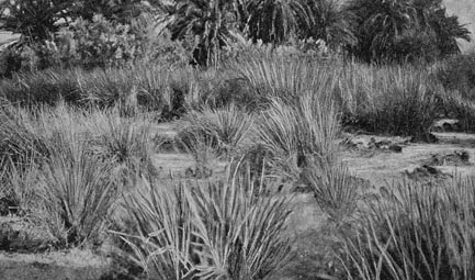
Ain Taba, photographed
by Alois Musil in 1902
|
Sources from the late Iron Age and later show that the wadi was a major crossing point for the Arabian trade to Gaza and Egypt. The camel caravans that carried frankincense, myrrh and other exotic goods from Arabia and India through the desert gathered in great trading centres such as the rock-cut town of Petra, before entering the Wadi Arabah and moving on to the Mediterranean coast and Egypt. Petra became the capital of the tribal kingdom of the Nabataeans, which extended on both sides of the Wadi Arabah. The Nabataeans also exploited the natural resources of the Wadi Arabah to the full, and the remains of their cultivation terraces are still visible in places in the wadi, although they are rapidly disappearing. Cultural remains on both sides of the wadi show that the trade between east and west flourished from an early period on.
There are at least two reasons why the Wadi Arabah forms a cultural landscape
of outstanding universal value:
• because it is a major crossroad on the Arabian trade route, which
ran from Saudi Arabia to the Mediterranean coast and Egypt, with a vital gateway
function
• because it was the centre of copper industry for a large region, and
as such provides unique information about all stages of the copper industry:
mining techniques, smelting and general copper working, and the economic influence
of this major industry on the region in all periods.
|